Popular political discourse today is dominated by discussions of the specter of “declining democracy." Depending on which news sources you subscribe to, the source and nature of the threats to democracy varies, but the consensus among mass-media, and many voters is clear. During the machinations of this decade’s redistricting cycle, partisans of all stripes and groups of all interests have, often rightfully so, found numerous examples of gerrymandering which qualify as damaging the democratic system. New York’s new congressional lines (those of the state legislature are just as bad, if not worse, but I will primarily be focusing on congressional districts in this article) are a clear example of this disturbing trend.
Incumbent protections, splitting of communities of interest, vote packing, splitting countries and localities unnecessarily, you name a core tenet of gerrymandering, New York’s new congressional districts are a lesson in that element of one of America’s nastiest political traditions.
I want to make it absolutely clear that I am not suggesting or implying that New York is the only egregious gerrymander to be attempted or enacted this cycle. Ohio, North Carolina, Maryland, Illinois, and Texas’ new lines are shamefully partisan in nature, and the successful legal challenges to Ohio and North Carolina’s maps are an excellent result for anyone hoping for fairer lines, and thus, fairer elections. (Though the Justice Department’s decision to sue Texas over the state’s new lines, but not to sue Maryland, even after the state’s governor wrote an appeal for his own state to be sued over its gerrymandered lines, is a less hopeful sign)
But the map drawn by New York is worse, primarily because, unlike Ohio, North Carolina, Maryland, Illinois (whose governor promised a commission and then abandoned the topic), and Texas, New York has an independent commission (or, given how the state legislature approached the body, had might be more appropriate). The independent commission was approved in 2014 with 57.67% of the vote in a statewide referendum; votes in favor of the commission were dominant both inside and outside New York City. The commission released two draft map plans, titled “letters” and “names”, for the State Legislature in early September 2021. (An analysis of these plans can be found here, from 538).
Both of these left the state with multiple competitive seats. The “names” plan created a new Long Island and New York City republican leaning seat. This proposed 10th district would have connected the heavily orthodox Jewish neighborhoods of Lawrence, in Nassau County, and Borough Park, in Brooklyn. The “letters” plan made the current 1st and 3rd districts, currently held by Republican Lee Zeldin and Democrat Thomas Suozzi, significantly more competitive, while also connecting the blue cities of Syracuse and Ithaca in upstate New York.
While these were not perfect maps (which easily becomes a highly subjective metric), both left intact New York’s previous balance of seats, which aligned well with the state’s political leanings. Furthermore, the maps largely left communities of interest intact, and did a much better job of this task then the newly adopted map.
In early January of 2022, the Republican and Democratic commissioners unveiled their proposals for the state’s congressional maps. These maps were arguably more partisan than the “names” and “letters” drafts, but, like their predecessors, left the balance of New York’s congressional districts mostly intact. While the Democratic map did pack Republican voters on Long Island into a north-south shore district which encompassed Smithtown and Massapequa, notoriously Republican jurisdictions on the island, it also preserved a Republican leaning Staten Island district and two upstate highly competitive districts. Likewise, while the current NY-03 became significantly more competitive under the Republican plan, it also connected Ithaca and Syracuse in a D+11 district, reduced the republican advantage in NY-02, and created a highly competitive Hudson Valley district.
However, the commission deadlocked and was unable to unify around a single map. So, New York State Democrats in the state legislature took control of the process, and drew their own maps.
Michael Li, senior counsel for the Democracy Program at the Brennan Center for Justice, called their map “a master class in how to draw an effective gerrymander” and added that “Sometimes you do need fancy metrics to tell, but a map that gives Democrats 85 percent of the seats in a state that is not 85 percent Democratic - this is not a particularly hard case.” Furthermore, the UNITY Map Coalition criticized the map for its “incoherent” breaking up of minority communities of interest.
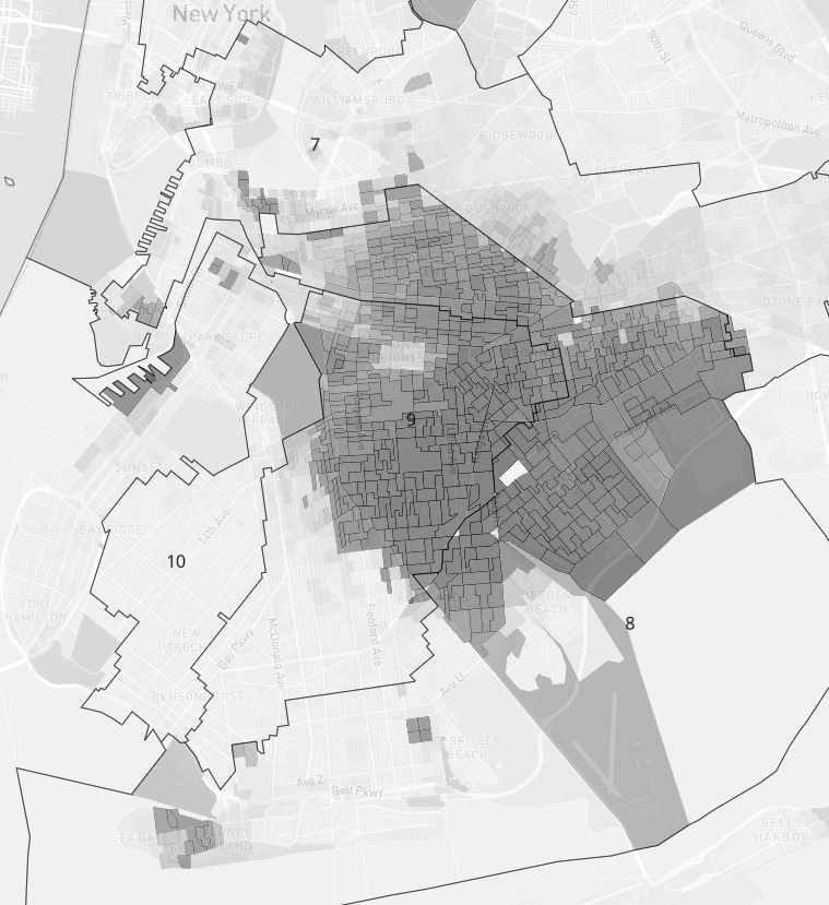
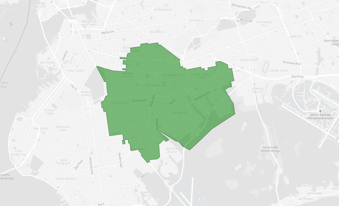
Uncomplicated examinations of the congressional map easily legitimize UNITY’s concern. The heavily African American communities in south-central Brooklyn, including Canarsie, Brownsville, and East Flatbush, are split nearly evenly between two districts, both of which turn an easily majority-black district into two plurality black districts. The 9th district, which includes Brownsville, cuts into Midwood, a neighborhood which heavily favored President Trump in 2020, and some of Bensonhurst, a neighborhood which has become decidedly more swingy in the past few election cycles. This district is one of three, along with the 8th and 9th districts, which carve up the Republican leaning areas of South Brooklyn. By contrast, the district shown below in green is 77% black. This percentage could be further increased by slightly lessening the district’s compactness, through cutting out the predominantly white neighborhood of Crown Heights to connect with other, more white areas to the district’s West, such as Park Slope.
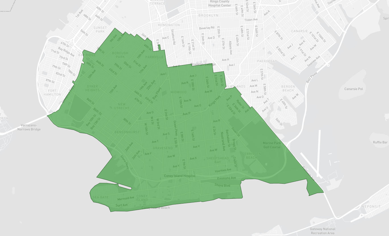
To demonstrate the partisan intentions of carving up South Brooklyn, this potential district, as shown above, which meets population requirements, comprises much of Southern Brooklyn, and was won by President Trump in 2020 by 19.9 points (59.4% to 39.5%). The district is 53% white, and keeps completely intact many distinct neighborhoods, including Borough Park (and that area’s Orthodox Jewish community), Sheepshead Bay, Bensonhurst, and New Utrecht. On the current map, parts of this district are in 4 separate congressional seats.
Then there’s Congressman Jerold Nadler’s seat, New York’s 10th Congressional district (below). The congressman now represents over a dozen blocks along Gravesend Bay, including Bath Beach Park. He also represents Morningside Heights and Columbia University. For anyone not familiar with New York City geography, that’s a nearly 20 mile drive across one of the most densely populated cities in the world, from the South end of Brooklyn to what can be called northern Manhattan, less than three miles south of the George Washington bridge. At times, and over dense city blocks, this district is less than 600 feet wide, being particularly thin as it passes by Atlantic Terminal. Manhattan Democrat Carolyn Maloney also gets a large boost, after continuously narrow victories over more progressive primary opponents, with her new 12th district lines shedding the ultra-liberal Astoria for more of Manhattan.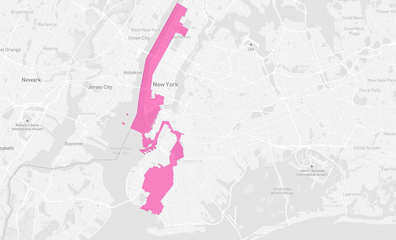
Lastly, little needs to be said about the blatantly partisan changes to freshman Republican and former New York City mayoral candidate Nicole Malliotakis’ Staten Island based district, which President Trump won by 10.5 points in 2020, and Mrs. Malliotakis flipped in the same year. Under its new lines, the district voted for President Biden by 9.5 points. This was done by shedding much of the district’s portions of southern Brooklyn (as mentioned earlier) and absorbing the very liberal, white neighborhoods of Park Slope and Gowanus, among others.
Upstate, the map is just as nasty, and, when viewed outside the partisan perspective, is just senseless. The new 16th district, held by freshman Democrat Jamaal Bowman, connects Eastchester in the Bronx, Mt. Vernon, Yonkers, and half of New Rochelle with…rural Putnam County. In the process, the district carves up counties which together have enough populations to form 3.3 congressional districts. And while Mt. Vernon and Yonkers may have much in common with the Bronx, upscale commuter towns in Westchester like Bedford, and rural Putnam county have absolutely nothing in common with these areas. One district over, the 17th district is just as, if not more, convoluted. The heavily diverse town of White Plains is connected to overwhelmingly rural, mountainous towns as far northwest as Liberty and Jeffersonville (a two hour drive with little traffic). While the district does keep together the extremely red Hasidic Jewish community around Kaser, in Rockland County, it just as easily remains on the South side of Route 17 barely long enough to avoid including Kiryas Joel, a rapidly growing (and just as red, President Trump won 98.6% of the vote in the primary precinct containing most of the town) Hasidic community of over 30,000. Meanwhile, Republicans Elise Stefanik, Chris Jacobs, and whoever wins the Republican primary in the open 23rd district held by retiring Rep. Tom Reed, have been placed (or rather, stuffed) in secure vote sinks, which President Trump won by 18.8, 19.8, and 20.7 points, respectively.
Finally, Long Island’s eastern three districts, all of which, since their drawing in 2010, have been competitive at some point over the decade, are mangled beyond recognition. The 1st district, held by retiring Rep. Lee Zeldin, who is running for governor against incumbent Democrat Kathy Hochul, extends from the easternmost reaches of Suffolk County (New York’s second largest county) approximately 85 miles into Nassau county to the neighborhood of Plainview. Along the way, the district conveniently siphons off a sizable portion of Smithtown’s Republican strength while also absorbing minority-heavy Wyandanch, Brentwood, and North Amityville. The district shifts from Trump + 4 (though Congressman Zeldin ran well ahead of President Trump) to Biden + 10.8.
The 2nd district, held by freshman moderate Republican Andrew Garbarino, becomes a Republican vote sink, designed to absorb as many of Long Island’s Republican voters as possible. About 50 miles of South shore Long Island is included in this district, which visibly skirts blue precincts. The perennial Republican powerhouse of Massapequa, in Nassau County, is combined with Lindenhurst, East Islip, Sayville, Holbrook, Holtsville, Medford, and Moriches, all steadfastly Republican areas. In fact, in the 2018 Senate election, the new 2nd district was less favorable to Senator Kirsten Gillibrand than the much more rural 21st district, one of the map’s upstate vote sinks.
The 3rd district, held by Democrat Tom Suozzi, who is also retiring and running for governor, contorts in completely unnecessary and partisan ways. The district now absorbs more than half of Republican dominated Smithtown (formerly in the 1st district) and extends along Island’s North Shore…through Queens, then the Bronx, and along Westchester County’s coast, all the way to the town of Rye Brook, a 1.5 hour drive through several of the most densely populated counties in the state.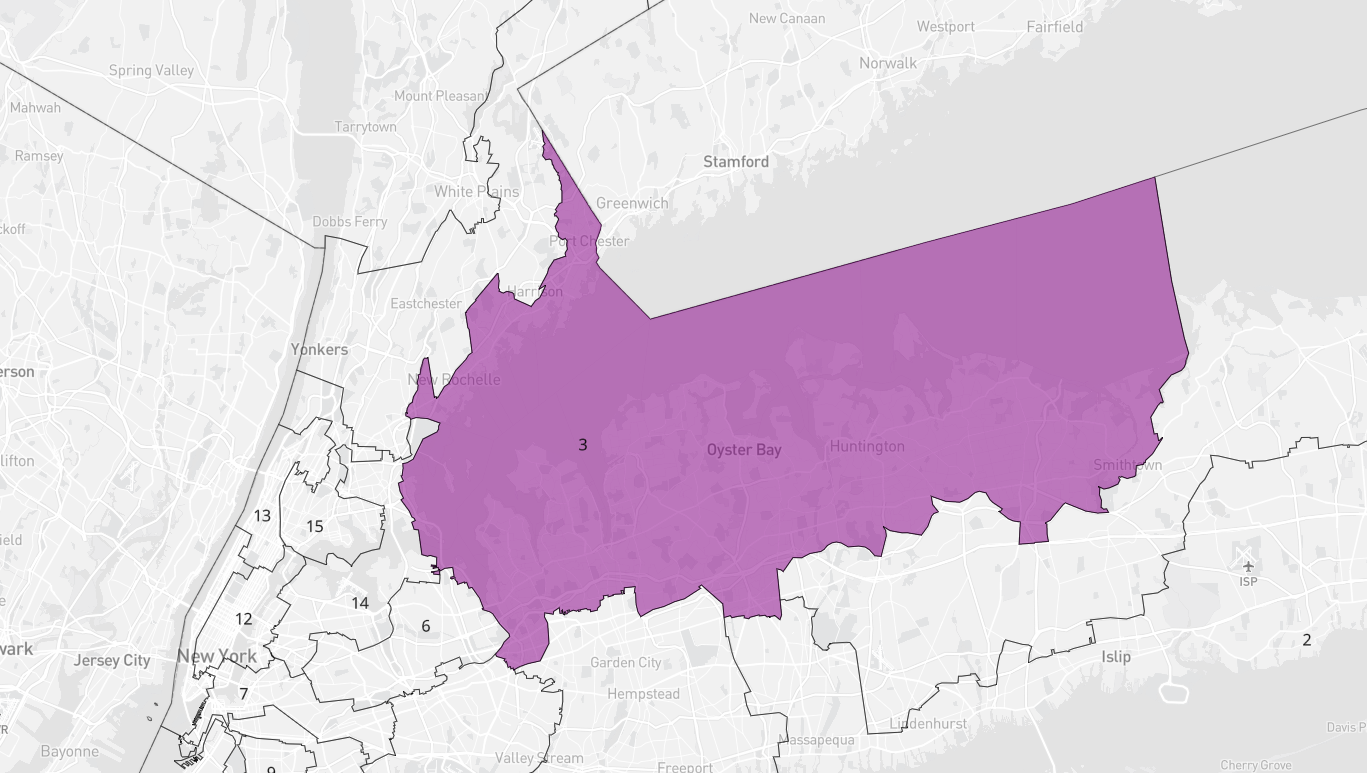
In sum, New York’s new congressional map represents one of the nastiest, most partisan gerrymanders in the country, if not the worst. Communities of interest are largely trampled over, while localities and counties are crudely split, and several lawmakers must now prepare to represent far-apart communities with little to nothing in common. Anyone who claims to support democratic principles, good governance, and fair elections ought to oppose this map, and support the lawsuit currently attempting to overturn it.
